<body><script type="text/javascript"> function setAttributeOnload(object, attribute, val) { if(window.addEventListener) { window.addEventListener('load', function(){ object[attribute] = val; }, false); } else { window.attachEvent('onload', function(){ object[attribute] = val; }); } } </script> <div id="navbar-iframe-container"></div> <script type="text/javascript" src="https://apis.google.com/js/platform.js"></script> <script type="text/javascript"> gapi.load("gapi.iframes:gapi.iframes.style.bubble", function() { if (gapi.iframes && gapi.iframes.getContext) { gapi.iframes.getContext().openChild({ url: 'https://www.blogger.com/navbar/17945780?origin\x3dhttp://gregoogle.blogspot.com', where: document.getElementById("navbar-iframe-container"), id: "navbar-iframe" }); } }); </script>
 

Google Earth or Google's Earth, take 2
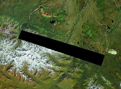
What are they hiding?

After reading this post by Colin Daniels, I published one titled Google Earth or Google s Earth? And I questioned if this programme is gate kept and if it actually offers transparency? Well, after finding this screenshot with this comment I begin to wonder how many sections in Google Earth are missing or are not shown in full quality. Is it fair for Google Earth to expose the rest of the world but limit the amount the public is allowed to see in America?

Oh and if you keen to see some South African military sites try these co-ordinates:

Simonstown Naval Base: 34”11’20.15” S / 18”26’15.02” E

Swartkop Air Force Base: 25”48’14.74” S /28”09’47.51” E
Waterkloof AFB Airport: 25”50’26.01” S /28”13’34.13” E
Grahamstown Air Base: 33”18’19.06” S /26”31’44.78” E

There